Saturday, October 15, 2011

Finally.... Haida Gwaii!

We've been married for 30 years. Yeah us!!
And for most of those 30 years we've talked & dreamed about making a trip to the Queen Charlotte Islands (now Haida Gwaii). As our 30th Anniversary drew closer we thought... "What better reason did we need?" Celebrate 30 years of marriage & exploring British Columbia by going on the ultimate road trip!
So the planning began. Those of you who know us know that we don't go anywhere without a plan & without doing a lot of research ahead of time. For us that's half the fun! If you're reading our blog right now because you're thinking of a trip to Haida Gwaii I hope you'll find this entry useful & helpful. I've written it with some how-to's, recommendations & must-do's!!

Before we left on our trip there were a few things we needed to do ahead of time. We reserved our spots on the ferry for there and back. Since the trip there was an overnight run we also booked a sleeping berth. I was very pleasantly surprised at our cozy little room on the Northern Expedition. With our own TV & bathroom and very comfy beds we actually slept a lot better than I expected. Another thing we did was book all our accommodations. We decided that we wanted to move around and explore different areas of the island so we reserved three different places - the Hecate Inn in Queen Charlotte City, the Sand Dollar cabin at North Beach Cabins near Massett and for the last three nights we stayed at Chateau Lawnhill in Lawnhill. The last thing we did (OK..I did) was put together a "Our Trip to Haida Gwaii" binder complete with copies of email correspondence, ferry confirmation numbers, special places we wanted to see and even a copy of tide table on the dates we planned to be there. The binder was also handy for writing down all the caches that I found during the trip. Yes I'm a geo-dork and just a bit of a type A personality!

Exploring Haida Gwaii was like being on the pages of a National Geographic magazine. Everywhere we went we were struck by beauty. I think Tony got so tired of me saying... this is soooo beautiful! But it was true. We spent a week exploring from one end of Graham Island to the other. Here are some of our favourite spots that we found...
RENNELL SOUND
black bear at Rennell Sound
Almost everything we read about Haida Gwaii said don't miss Rennell Sound so we figured that we'd better make sure to go there. Well the books weren't wrong.
We went to the sound on our first day on the island. We sure enjoyed the drive there....driving through beautiful forests on gravel roads has always been one of our favourite pastimes! We knew that there was a steep hill at the end of the drive but Tony managed the 24% grade like a pro! After the hill we continued on to the trail head for Gregory Beach. I was excited to learn that there was a cache hidden on this trail... just another bonus for visiting here. After we found the cache (GCX55R) we continued on down the trail to the ocean. Wow is all I can say! Rennell Sound is the only west coast beach that is accessible by road and apparently one of the best beach combing beaches on the entire west coast of North America. We didn't find anything special that day, no beautiful sea shells and no coveted glass fishing floats, but we did see an enormous black bear walking along the beach ahead of us. A once in a lifetime experience! Thanks to geobyrd for the great cache...absolutely one of my all time favourites and one I highly recommend!

THE GOLDEN SPRUCE
sad end to Kiidk'yass
A beautiful legend & a mystery all rolled into one....that is the story of Kiidk'yass or the Golden Spruce. Kiidk'yass was a tree with a rare genetic mutation that made its needles yellow. For centuries the Haida Nation had revered Kiidk'yass as a mythical force... sitting on the banks of the Yakoun River, it was a thing of beauty and according to the Haida, would be there till the end of generations. Then in 1997 an eco-terrorist named Grant Hadwin cut the tree down as "a wake-up call" against industrial logging. The logic of this act escapes me but that is not the end of the story. Released on bail, Grant Hadwin disappeared while on the way to his trial. His broken, abandoned kayak and belongings were found on a remote island but no trace of Hadwin was ever found or has been found since.
Fortunately, about 20 years previous, cuttings had been taken from Kiidk'yass by a group of botanists from UBC. After the Golden Spruce was felled UBC offered one of the new golden saplings to the Haida people which they accepted and planted near the base of the original tree.
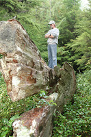
Today, beside the Yakoun River, you can still see the once mighty tree, now lying on its side, with a brand new yellow spruce planted at its roots.
The 10 minute walk to the Golden Spruce is accessed from the road to Juskatla and takes you past some of the most amazing old growth forest we have ever seen. Of course there's a geocache there too - thanks geofran - (GCXE4C)... just another reason to come to the wonderful place.

NORTH BEACH
We arrived at our cabin on the very northern end of Graham Island on a beautiful sunny day... perfect timing to explore this amazing area. If you love long walks along the ocean (like me) then this is the place for you... sandy shoreline as far as the eye can see. Just to put it in perspective, Long Beach, on Vancouver Island is about 25km long. The continuous length of sandy beaches on Graham Island starts at Massett, continues all along the north coast, around Rose Spit and down to Tlell on the east coast, approximately 100 kms of sandy beach. Incredible and just waiting to be explored.

TOW HILL & NAIKOON PROVINCIAL PARK
below Tow Hill
Tow Hill, on the northeast end of Naikoon Provincial Park is a volcanic plug that stands out above the tree line, easily seen from miles away. The 45 minute hike to the top is an easy one since the whole trail is a boardwalk! First time I've ever seen that. At the top you'll find a cache appropriately called "Beware of Cliff" (GC2X0VQ) and a view that is awesome. On a clear day you can see Alaska. Really.

THE WRECK OF THE PESUTA
The Pesuta Shipwreck was the one "must-do" that we never made it to. Weather, time constraints and high tides all made it a little difficult to get to but we have some friends who went there this summer and they really enjoyed the hike there and exploring the wreck.
HAIDA CANOE
It's one thing to see history in a glass case or read about it in a book. It's an entirely different thing to see it and touch in the middle of the rainforest. That was our experience when we hiked to one of 4 Haida canoes that have been abandoned on Haida Gwaii. No one knows why these half finished canoes were left to rot but they were. Were they not carved properly? Did they crack? It's a mystery and we love mysteries. You'll find the trail head for the Juskatla Canoe at N53 36.145 W132 16.913 and the canoe at N53 36.121 W132 16.701.

HAIDA HERITAGE CENTRE
This 26 million dollar museum & Heritage Centre in Skidegate is incredible. From the huge authentic totems to the tiny baskets woven with spruce roots... well worth the $15 entrance fee.

BALANCE ROCK
Balance Rock is a huge glacial erratic just north of Skidegate that sits perfectly balanced on the point of another rock in the middle of a beach near Skidegate. "Rock-In-Out" (GC21AMY) is the perfect cache at this location. You've got to see it to really appreciate it.

There are many places to stay on Haida Gwaii... from campsites to B&Bs. The pitfalls of reserving a place through a website is you never know if it's as good as it looks in the pictures! We were fortunate to find three very good ones and I'd highly recommend each one of them.
HECATE INN in Queen Charlotte City was clean and quiet. We had our own apartment with a separate bedroom and kitchen which was great for making our own meals. They also had internet access which can be pretty important if you need to keep in touch with your family. NORTH BEACH CABINS was the most rustic of the three places we stayed. The Sand Dollar, which was our cabin, had no electricity but it was cozy with a propane stove & heater and the incredible North beach was only minutes away. Lisa, our host, has added all sorts of beautiful touches to make her place special... even stained glass windows in the outhouses! CHATEAU LAWNHILL was the last place we stayed and from the moment we arrived Ron, our host, made sure we felt at home. We appreciated all the advice he gave us for exploring the island and sure enjoyed the huge salmon steaks he brought us!

Before we knew it our week had come to an end and it was time to head home. We really hated to see it come to end... there was so much more we would have liked to see but well, reality beckons.

The wonder & beauty of Haida Gwaii is not something we will soon forget. It truly was the trip of a lifetime.

Thursday, September 1, 2011

My Day with the Baerg Family


Mount Cheam, British Columbia
When I was about 10 years old my dad went on a mountain climbing hike with a bunch of guys from our church. Their goal? To climb to the top of Mount Cheam. I remember him coming home that night absolutely exhausted but full of stories to tell. Later when I saw the photos...all these guys standing at the top of the peak with nothing but glorious blue sky all around them...well I knew that someday I wanted to be there too.

Fast forward to 2011... almost 40 years had past and I still hadn't achieved my goal. And I was getting a little frustrated. Every time we would drive by the mountain on the freeway I would say, "Someday I'm going to get up there." I think Tony stopped listening to me. Then I discovered geocaching and sure enough, before I knew it, there were a bunch of caches hidden along the Cheam trail and two on the peak! Now I really have to get there!

Climbing Cheam (or any mountain for that matter) is not something you do lightly or something you do alone. Unfortunately for me, Tony is not interested in climbing any mountain unless hunting or fishing is involved, so if I was going to get up there, I had to figure out how to do it on my own.

Enter my good friend Carol (in geo-caching world aka Nurse Hatchett). Carol's family, the Baergs, have a family reunion every three years and every six years one of their family reunion traditions is to climb Cheam. They've been climbing the mountain since the 1970s & this year Carol invited me to join them.
I've decided I really like this family.

So on August 27th, one day after my 49th birthday, I became a member of the Baerg family for a day. I was so excited.

The forecast was for perfect weather and it did not disappoint. Not a cloud in the sky. Perfect.
We all met near Bridal Falls and 15 of the Baergs, plus me, packed into some borrowed trucks to make the trip up the Chipmunk Creek FSR to the parking lot at the trailhead. The road up to the trailhead is rough, to say the least. In order to keep the snow melt from turning the road into a river in the Spring, there are cross-ditches dug every 200m or so... makes for a very interesting ride in a big pickup loaded with people. Once we got to the parking lot we noticed that the truck with all the teenagers was no longer behind us. We waited a bit and finally we asked some other hikers who came up shortly after us. Had they seen a truck full of young kids? "Oh yah," he said, "They had major car trouble." Great.

I wondered what we were going to do. Were our plans to climb the mountain all for nothing?
But it soon became apparent that the Baergs are not a family that gets into an uproar too easily. By the time Rick (one of the dads) decided to head back down to rescue the kids most of them had already hitched rides up to the parking lot. Thank goodness for Good Samaritans! So let's hike...we'll worry about the truck later!

The alpine meadows on Mount Cheam are incredible. I lost track of how many different mountain flowers I saw and the geocaches were placed just right so that I could use the excuse that "I am looking for a geo-cache" instead of "I can't breathe anymore & my legs are on fire."

There are 12 caches on the way up to Cheam Peak and we found 8 so I was pretty happy with that. I really wanted to find at least one cache on the peak and was happy to find CHEAM - GC1F94M at the top....wow! is all I can say about this cache location. There's another great view from GC2EJ9G and GC1FCKC really was a great spot to take a break! All the caches we found that day were well done and I highly recommend them all.
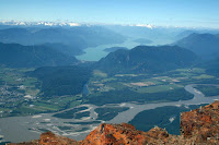
View to the north from Cheam Peak


Mary & Elizabeth


Carol & Me at the top!
The family trudged on & on, the younger set moving at a quicker pace while the rest of us went just a little slower! At this point I have to tell you about the two oldest members of our hiking crew.... Mary & Elizabeth are Carol's aunts... they've been on almost every Cheam hike since the Baerg family reunion began... and they are now 80 & 82! I was pretty impressed by all the beauty that surrounded me but these two ladies and their determination impressed me the most that day.

About 2 hours later we stepped onto the ridge at the top of the mountain. I was absolutely speechless which is, if you know me at all, quite something. The view was overwhelming. A 360 degree view of the Fraser Valley. Unbelieveable. I had waited 40 years to get here and it was worth every minute.

And that should be the end of the story shouldn't it? But it turns out that our day of adventures was not over yet. Once we all got back down to the parking lot, piled into the one truck that we had left and started backing out it soon became apparent that there was now something wrong with this truck. The power steering was gone! But once again, the Baerg family did not panic... the truck has just enough maneuvering capabilty to navigate the road and our driver, Rick, has, apparently, pretty strong arms. As we start down the road I hear Rick's wife, Annette, ask him quietly, "How's it going?" And he says (also very quietly), "I don't think I want to tell you.... we have no brakes either."

Are you kidding me?
I thought coming down the trail on Cheam was tough but this was brutal. Hairpin turns, gravel road, cross ditches & major cliffs. It took us almost 2 hours to drive 6 kilometres... the whole trip in first gear. But you know, as we turtled our way down the mountain, with Rick white-knuckling the steering wheel, that family visited and reminisced and laughed....mostly they laughed. And I realized then that they were making another family memory. A great one. One that they'll talk about in 6 years when they climb the mountain once again. They'll laugh and say "Remember the last time we were here and the trucks all broke down? Wonder what adventures will happen to us this time?" And maybe they'll ask me again if I want to come along.

the Baerg Family - at the top! August 2011

Thanks, Baerg family, for the awesome adventure. And thanks for the memory.

I finally did it!

Tuesday, August 9, 2011

History Lessons


under the overhang on the Birkenhead river
There are some places in our province that just exude history....where you can almost feel the past enveloping you and hear the voices of those who walked before you. Lillooet Lake is one of those places.

This past week my daughter and I had the pleasure of joining our friends at their cabin on Lillooet Lake. Joan & Werner built their cabin almost 30 years ago and so they already have a rich knowledge of the area's history but they are always willing to go exploring again, especially when they have an amateur historian along! (that would be me!) And, as it happens, there are new things to find & discover, even for them.


Mountain Goats?
We started our history lessons that first evening by boating down to the north end of Lillooet Lake and into the Birkenhead River. Joan had recently read in a magazine of a kayaker who had spotted some pictographs on the cliffs along the river so we had our mission. It took about an hour to get to the mouth of the river. I think that maybe Joan had a few frayed nerves wondering if the river was deep enough for the boat but it was all good. As we quietly floated down the river one could not miss the tangible change in the air around us. "This is spooky." Joan said and I knew we were in the right place. There they were... up on the cliff right above us... the bright red drawings that we now recognize so well. We landed the boat (not as easy as it sounds!) and bush-wacked our way to where, long ago, someone decided that for whatever reason this story needed to be told. There are only two paintings there but both are in great shape. One of an animal under a arc and the other... two mountain goats climbing a hill. The paint is still so bright and the images so clear, it could have been painted yesterday.

The next day we geo-cached around the Pemberton area. The walk around One Mile Lake was especially lovely and we really appreciated the 7 cache series that had been hidden there by fisher007. Each hide was inventive and unique, the hints were fun and the whole series takes you around this pretty little lake where you end up right back where you started. We also appreciated the caches hidden by Tourism Pemberton. Well done! Hopefully more towns in British Columbia will follow your lead!

Our next history lesson took us down Lillooet River Road which was, for the most part, built over the old Douglas Road. We especially wanted to see the Church of the Holy Cross (in Skookumchuck) and see what we could learn about the Mile Houses built along this road.

The Douglas Road or Harrison Trail was conceived by Governor Douglas to accommodate the steady rush of men heading to the Cariboo Gold Fields. Paddlewheelers & steamers on the lakes made parts of the journey relatively easy - it was in between the lakes, the portages, that was the trouble - so the Douglas Road was born. Of course it didn't take too long for enterprising men to realize that travelling over this rugged, mosquito infested land would create some very weary travellers and before too long "Mile Houses" (hotels) were springing up along the way.


Old graveyard beside the Road
Today, as we pass the occasional house or car, it's hard to imagine that over 30,000 men used this route in just a few short years. By 1861 it was all but abandoned for the Cariboo Wagon Road and now we have to use our imaginations to picture this as a busy road. The Mile Houses are all gone - there's the occassional apple tree here and there - but at one time they were full of hungry and tired men looking for a meal and a place to sleep.

One place that does still exist is "20 Mile House" or "Hot Spring House" - the home of Skookumchuck Hot Springs. Though none of the original buildings are standing today it is not hard to see why this would be a most welcome place to stop along the journey - the chance to have a hot bath. One book we read quoted the aid of Judge Matthew Begbie as saying "This is the first time I've been clean since I left San Francisco!" Yuck.

After leaving the hotsprings we continued south to the village of Skatin (formerly Skookumchuck). This is the location of the Church of the Holy Cross. I don't know what I was expecting when we drove up to Skatin. This place is remote... there isn't a town for miles & miles, so I think I was expecting a little country church. This is so not a little country church! Inspired by prayer cards they had been given by visiting priests in the late 1800s, the residents of Skookumchuck, who had no architectural training and no power tools, designed a wooden gothic-style 'cathedral.' European cathedrals are made of stone but the builders of Holy Cross used the resources that were available to them. Huge cedars were milled for the foundation and placed on stones taken from the Lillooet River. Inside, the altar and stain glass windows are gorgeous and all handmade. Unfortunately time & the elements of the west coast have taken their toll and the church is in bad need of restoration. We left a donation in the drop box inside the church but I wish I could have done more. This spot really touched my heart. Maybe it's because it was such an unexpected & wonderful surprise - a huge church in the middle of the forest - or maybe it's because I work as an church administrator and I know how hard it is to keep a church building maintained. If you'd like to read more about the Church of the Holy Cross (or even make a donation) you can visit their website.  


The interior & exterior of the Church of the Holy Cross. Amazing!
If you're ever in the Pemberton area I highly recommend a road trip down the Lillooet River Road. We explored & geocached, visited a beautiful old cemetery, saw a black bear, visited a hotspring, took in all the breathtaking scenery and stepped inside a 100 year old church. As far as I'm concerned that's about as good as it gets!

Once again our time at the cabin has ended all too quickly. We had such a good time with our awesome friends and we appreciate their hospitality. We're already looking forward to next year and, hopefully, a bunch of brand new history lessons to learn!

Thursday, June 30, 2011

Back in Time to Barkerville

I had barely got home from Alaska and two days later I found myself on a road trip with my 'sisters.' I knew this was coming but still felt like I needed a little time to catch my breath. No such luck! Every year I take a trip with my friends. We call ourselves the Seven Sisters though, sadly, there is rarely a time when all seven of us manage to get together anymore. Last year we went to Disneyland (incredible) and this year we thought we'd try for something completely different. Barkerville, British Columbia.

Billy Barker
In 1862, Billy Barker came down the Williams Creek valley from the town of Richfield in search of a rich strike. After digging through 42 feet of hard clay he found the richest strike to date in August of 1862. After spending the winter of that year in Victoria, Barker returned to his claim in the spring only to find that an entire town had been built around it and was named in his honour. Barkerville had been born!

The wonderful thing about Barkerville is that that same excitement (read 'gold fever') and historical accuracy have been painstakingly preserved to this day. Over 100 of the buildings are original and many are standing in the same spot they were built. Townspeople wander about, seemingly oblivious that you are from a completely different timeline. A hurdy-gurdy girl told us that contrary to what we had heard "she didn't do that sort of thing" and a wobbly lawyer weaved down the street in front of us after one too many visits to the "apothecary." At least he never forgot to tip his hat. To really enjoy Barkerville here's my advice. Just let yourself be transported back in time.

For those of us who live in the Fraser Valley, a trip to Barkerville means travelling up the Fraser Canyon. It is one of my favourite road trips. After you pass through the historic town of Yale you can almost feel a palpable change. Time slows down just a teensy bit and the history envelopes you as you travel along the same road that so many went on before, risking their lives for that one thing. Gold.

Now, almost 150 years later, we whiz along in the comfort of our automobile. It doesn't take long and you go through the first of seven tunnels. Do you know the names of the tunnels off by heart? Thanks to my father, the school teacher, I do. I've tried to make my friends memorize them but they don't seem very interested. Not sure why but since this is my blog I'm going to recite them for you. They are (from south to north)...Yale, Saddle Rock, Sailor Bar, Alexandra, Hell's Gate, Ferrabee and China Bar (the longest).

the 8th tunnel

It is at the Hell's Gate tunnel that we make one of our first stops. Did you know that there is an 8th tunnel? I didn't either until we went to look for GC29TEX - what a wonderful surprise that was! If you're travelling and caching up the Fraser Canyon this is one cache that I highly recommend.

The Sisters at the Kelly House

There are far too many wonderful spots to explore and caches to find along the Fraser Canyon to list in one blog entry so instead I will recommend two excellent books you should have for a trip like this... especially if you're a geocacher. The first one is Gold Country's "GeoTourism Adventures" and the 2nd is New Pathways to Gold's "Chasing the Golden Butterfly." We love them both, especially when someone reads them aloud to us while we're driving! 

When we arrive in Barkerville we are pretty excited because, months ago, we booked the "Kelly House" as our accomodation. A Bed & Breakfast right in the heart of Barkerville means that we can explore to our heart's content and go back whenever we want - to rest, to eat or for a glass of wine! Not only is it convenient but the back-in-time illusion continues with feather beds (honestly, the best sleep I've had in a long time), clawfoot tubs, no TVs & a Cariboo breakfast every morning. Because there was no TV we read aloud in the parlour every night from "Cariboo Runaway." Great story. 


We spent three days exploring Barkerville and yes, you can and you should spend at least that many days there. We took the Barkerville Cemetery tour, panned for gold, took the Barkerville town tour, took the Chinatown tour, visited with an archaeologist, hiked to the Richfield courthouse, rode on a stagecoach and of course, got our portrait taken at Louis A Blanc Photographic Gallery. We found all seven caches around Barkerville and they're all great and well done. My favourite though was GC12A7A because, in order to log this cache, you need to watch the Cornish Waterwheel show.. one of the best shows in Barkerville!

After a wonderful three days it was time to road-trip home. We drive south, through Spences Bridge, Lytton and Boston Bar and then, before we know it, the familiar Fraser Valley farmland stretches before us. We're home. It is good to be home again but we know that life is going to speed up any minute now. The illusion was wonderful while it lasted.


Wednesday, June 15, 2011

Cachin' & Cruisin' Alaska Style

I've done a lot of geocaching & exploring in my life but nothing like this last trip!

On June 7th my daughter and my parents and I set sail on the Disney Wonder from Vancouver to Alaska. People told me that cruise ships are luxurious and that you are treated like royalty. Well that was an understatement. The moment we stepped on the Wonder we forgot that we were regular people! It was beyond our expectations.

I could tell you now all about our Disney experience but that's a topic for a different blog. What I'd like to share with you is our experiences in the towns of Alaska.... Ketchikan, Skagway, Juneau and the fjord of Tracy Arm.

I am a West Coast BC girl so to be honest with you Alaska is not a whole lot different from home. But still, as far as I'm concerned, there is no place like home! The coastlines of British Columbia and Alaska are breath taking and each port of call gave us something new to see and explore and, of course, caches to find!

My family & me in Tracy Arm Fjord
Our first Alaska experience was Tracy Arm. Tracy Arm is approximately 48 km long. The cliff walls of the fjord loomed high above us as we made our way slowly towards Sawyer Glacier. We saw many seals with their pups and an eagle sitting on her nest. We scanned for mountain goats but unfortunately we didn't see any. As we got closer to the glacier the ice floes around us increased. Some of these chunks of ice were as big as a car. Suddenly we heard a loud boom, like two railway box cars banging together. The glacier was cracking! We didn't see any 'calving' (parts of the glacier falling into the sea) but even the sound of it was awesome. The forces of nature at work are pretty humbling. At this time I got to experience my first "cruise-friendly" cache. GC1DG1T is an awesome earthcache that you can complete from the deck of your ship. All you have to do is answer a few questions and have your picture taken with your GPS and the glacier behind you. Since our ship made sure that there were Park Rangers on deck available to answer all our questions as we passed through the fjord, this was the easiest cache I had done in a long time.

The White Pass Train
The next morning we awoke to find that we were already docked in the tiny town of Skagway. Skagway is one of those places that exudes history and there's not many things that I love more on this earth than history, especially when I can walk amongst it. This was the day that I had been looking forward to for months. Today we were going to ride on the Whitepass Historic Railway. The White Pass Railway was built in 1898 and has been declared an International Historic Civil Engineering Landmark, a designation shared with the Panama Canal, the Eiffel Tower and the Statue of Liberty. The 4 hour ride took us through tunnels, over trestles, past the cabin where the North West Mounted Police checked every miner entering the Yukon (to make sure they were carrying at least one ton of supplies with them) and into British Columbia. We were allowed to walk around inside our train car during the trip and we could even step outside onto the small decks at each end of our car to get some awesome photographs. If you're in Skagway I highly recommend this excursion.

Skagway had some fun caches. One, called Altoids Alaska, was an easy find and just steps from our cruise ship. I sure appreciated that. We found a great TB hotel not too far away as well but our favourite cache was a Virtual called "Camp Skagway No. 1" GCGJ2Q. If you're caching in Skagway this cool virtual should not be missed.

The Wonder from Mount Roberts
The next day we docked in Juneau. The captial city of Alaska is beautiful and has the distinction of being the only state capital that is not accessible by road.. the only way in and out of Juneau is by boat or plane. Before we disembarked we had breakfast on the ship while watching the floatplanes coming in and out of Gastineau Channel. We commented on how much it reminded us of Vancouver... a city surrounded by ocean & mountains. Once again we felt right at home. We had previously decided that we weren't going to do any other excursions during the week but, after we got off the ship, my dad took one look at the tram going up to Mount Roberts and said "I want to go on that!" Well my mom does not enjoy heights too much so Tess, Dad & I took the trip up. It was a great ride up (a little pricey) but it was beautiful at the top with views that were amazing. My advice if you're planning on visiting Juneau is to wait and see what kind of weather you have that day when you arrive. If it's cloudy I don't think it would be worth the cost of a ticket since you won't be able to take in the great view... and if it's nice you can easily buy your ticket after you dock.

All too soon it was time for our last stop... Ketchikan. Ketchikan, the "Salmon Capital of the World" was such a cute little town with most of the shops right beside the docks. We enjoyed walking the streets, dodging the jewellery merchants just a bit (lol) and, of course, finding a cache or two. Unfortunately there weren't too many to find right by the cruise ships and we didn't have much time at this stop but we did manage to find one micro GC2D1CH after a great walk along the pier.

And then, before we knew it, we were heading home, back to Vancouver.

What a vacation that was. We were spoiled beyond belief, ate like we had never eaten before and explored to our hearts' content. Alaska was just as welcoming, breathtaking and beautiful as I expected it to be. I'm sorry that our trip is over but the memories we take home with us will last us a life time.

Thursday, May 19, 2011

Road Trip!!

I know that most of you who read our blog are from British Columbia and you love exploring our beautiful province as much as we do but I hope you'll indulge me for the next couple of months. Two of our major "caching holidays" this year are taking place in 'other places' - one will be a Disney Cruise to Alaska (in June) and I just got back from the other trip... a long awaited ROAD TRIP to South Dakota!

If you have read some our previous posts you know that we LOVE roadtrips. I was never the child who said "when are we going to get there?" There was just so much to see along the way! And I'm happy to say that nothing has changed.
Ready to Leave!

Last week I flew to Saskatoon to meet my friend (who lives there) and, the next morning, along with two of her friends, we started our journey.

The key to good geocaching is planning, especially for a road trip. I started building our pocket queries months ago for this trip... 'caches along a route' is so great for just this kind of journey. I loaded about 400 caches that took us along a 'paper clip' shaped route so that we would hit as many states as possible. From Saskatoon we headed south, through Montana and Wyoming and into South Dakota. We realized then that we were pretty darn close to Nebraska so why not make an extra trip there too? After we spent 3 days exploring the Black Hills we headed north through North Dakota and back into Saskatchewan. We were gone six days and it was the perfect road trip.

The Black Hills are an unexpected, awesome experience in, let's face it, a mostly unassuming prairie. They kind of sneak up on you.. suddenly you are in mountains. For someone from British Columbia, where mountains are an every day occurence, this was a pleasant surprise.

The streets of Deadwood, S. Dakota
Our first task was to find a place to stay and so we decided to spend three nights in Deadwood, South Dakota.
Ahhhh.... Deadwood. A whole lot of casinos, laughing laid back people, great food and a ton of geocaches. It was like stepping back in time and living right in it. We ate in #10 Saloon where Wild Bill Hickock was killed and in the Midnight Star that is owned by Kevin Costner. We visited the grave of Calamity Jane, saw wild deer walking along the canyon walls of Deadwood Gorge and of course found as many caches as we could. It's been a long time since I've enjoyed a town so much. If you're in South Dakota DO NOT miss Deadwood.

Crazy Horse Memorial
Once we had set up 'base camp' at the Holiday Inn in Deadwood we got down to some serious sightseeing & geocaching. On our first day we decided to see "Crazy Horse." Work on the world's largest sculpture began in 1948... Crazy Horse is a massive undertaking.... a sculpture of the Lakota hero to match the presidents on Mount Rushmore. His face alone is 9 stories high. Our favourite cache at this site was an earthcache GC2C5RG. By the time we explored everything to see at this site the weather had turned and the clouds were looking pretty dark. Instead of continuing on to Mount Rushmore we decided to head back to Deadwood and hope for better weather the next day.

The next dawned bright and sunny but it sure was windy! We found out that those black clouds brought a tornado with them so we were pretty glad we had called it a day!

Mount Rushmore was everything that we had hoped for and more. Pictures do not do it justice. The first time I saw those gigantic faces on the mountain it took my breath away. For the next 4 hours we just enjoyed the experience. We ate at the Carver's Cafe, took the guided tour, watched the documentary and snapped about 100 pictures. And of course we geocached. There are no caches on the official site of Mount Rushmore but there are plenty in the vacinity. Our favourite was "Wrinkled Rock: What's Really Behind Mount Rushmore?" GCY8HG. Great little hike in the Black Hills.

After leaving Mount Rushmore, rather reluctantly I might add, we decided to travel the Needles Highway a bit. Wow! I consider myself a seasoned BC mountain driver but this highway was something else. I had never driven a 'pigtail' before... let's just say it puts a whole new spin on hairpin turns! Near each 'pigtail' is a single lane tunnel and the dakotahillbillies have hidden a cache at each tunnel. Each of these caches was an awesome experience.

All too soon it was time to head home. Out of the 400+ caches that I loaded we found about 60 of them.... besides the ones that I mentioned above, here are a few more of our favouries: Rocky Wall (Montana GC2RPTN), Open Range (Montana GC1157M), Sunday Gone Wrong (South Dakota GCGDGG) and the Deadwood series in the town of Deadwood, South Dakota.

And that is just a small taste of our latest road trip. I want to say thanks to LaurieAnne, Leona & Anna for joining me on this journey. Sure enjoyed the ride.


Wednesday, March 16, 2011

What 2000 Caches has Taught Me

I am sure that Tony, my skeptic (here he would say 'realist'), my "the-glass-is-half-empty" husband, was sure that this "geocaching thing" was just another phase that I was going through. And I have to admit that he did have reason to think that. I have gone through a few phases (OK, a lot of phases) during our marriage...ceramics, tole painting, plastic jewellry and countless cross stitch projects, just to name a few. But after nearly 4 years of exploring and hiking, seeking and finding... well, I don't know why but geocaching is still as fun for me as it was when I first started.
I would really like to tell you why. Why has this hobby 'stuck' and the others haven't? Not sure but here I am celebrating 2000 finds!!

My 1000th find was just Tony & me in Vernon, my 1500th was with my friends Carol & Joan at the remote Crater Lake in the Cariboo. This time I wanted to include as many of my friends as I could who have helped me get to this point.

It wasn't easy to arrange.. between work schedules and days off we finally came up with March 13th. The day dawned bright and sunny... NOT! This is the west coast in March after all... we haven't seen the sun in, well I don't know how long.

So, after church on that Sunday, we all met at my house. We brought the appropriate and requisite rain gear. My friend Lorraine had a bright blue suit from the Vancouver Marathon. I only mention it because Lorraine can barely say the word 'marathon' without grimacing let alone participate in one...but I digress.

The spot I chose for my special day was the Cheam Wetlands... quite ironic since we were trying to say dry! Really, this was a beautiful spot, a birders paradise. Apparently up to 200 different spieces of bird have been spotted here. Cheam Lake Wetlands became a park in 1990 and is popular for hikes, picnics, and or course, bird watching. The 93 hectare park is recovering after being mined for marl limestone deposits for 50 years beginning in the early 1900's.

My 1000th and 1500th caches were both Traditional finds so I decided that this one needed to be different. I LOVE earthcaches and so I chose the Cheam Lake Earthcache to be my milestone. Earthcaches are always so rewarding because, in order to get that smiley, you usually have to meet quite a few requirements and usually I learn something that I never knew before. This one had five requirements... not too bad and not too hard. We were doing well when suddenly I noticed that we had to find some 'marl' and post the coordinates of where we found it!! Trust my friends to rise to the challenge... the hunt was on!

I had never heard of marl before today so I had no idea what we were looking for. We re-read the cache page notes and then started looking. We finally found some near another cache site. Marl is like clay only kind of spongey. We were celebrating the find when I realized that this was it... 2000!! "This is it" I said, "We need to take a picture!" That's when my friends surprised me. Joan had made a wonderful banner just for the occasion! We took a bunch of pictures and I did a little dance on the trail right there. Yes, I am a dork.

It was a good day, actually a great day. Not only because I reached another milestone in this hobby that I love so much, but because I was reminded about how lucky I am to have such great friends to do this with me. They have been there with me on so many hikes and walks, on trips into caves and under waterfalls. They have been bruised & scraped, fallen & tripped. They've (very reluctanly) eaten lunch in parking lots and have bushwacked through unrelenting blackberry bushes. They did all that and more just for me.


I couldn't think of a better way to celebrate 2000 caches.


Wednesday, January 19, 2011

Texada Island - Our Happy "Caching" Place

Well we just got back from Texada Island. Our 5th visit and it was of course just as wonderful as it's always been. We rent the same little place with an incredible view of the ocean right beside Shelter Point Park. It's quiet and peaceful and we just renew & rest.

There is only one thing wrong with our perfect retreat now... there's only one more cache left on the island for me to find!

So I thought that I'd write this post as my "How to Cache Texada Island" entry. If you are planning a trip to this wonderful place and you want to do some caching this should help.

There are 12 caches on the island and there isn't one that I wouldn't recommend. But first you need to get there. If you're coming from the Lower Mainland of BC and you'd like to cache along the way you probably want to do a couple of pocket queries for the trip. You are most welcome to use my public query. It's called "Horseshoe Bay to Powell River." It will give you every traditional cache that is within 2.5km of the 101 Highway.

The trip to Texada is a beautiful road trip but it's also a long one. As the crow flies it would be pretty short but, well where in BC can you travel as the crow flies?

You'll need to take three ferries, one from Horseshoe Bay to Langdale... then drive about an hour to Earl's Cove where you'll take a 40 minute ferry ride to Saltery Bay. One more 30 minute drive to Powell River and you're almost there. A 35 minute ferry ride to Blubber Bay brings you to Texada Island, the Emerald Island. Welcome.

1. The very first cache is GCRMDY - Blubber Bay. This cache is just a few metres from the ferry terminal in some large boulders. Save it for when your waiting in the line-up for your ferry ride home.

2. The next cache is GC1C1QR - Texada Geo Guide. This is the cache that you want to grab first. It's absolutely brilliant in that it has a printed guide for every cache on the island. I really think we need one like this for the lower mainland! Kudos to Batwinged Hamburger Snatcher for coming up with this great idea. Perfect for the cacher that doesn't have any time to waste in an area that they may not know very well.

3. Glass Beach - GCXZPW, is next and it is one of my all time favourite caches. In 5 years of caching I've never enjoyed a site more than this spot... not so much for the scenery, which was awesome, but for how this spot touched me in a personal way. You can read more about my experience at this cache here. Don't miss this one.

4. After Glass Beach is a multi GCW6D8 - Nearly Cache a Woozle. This one involves about a 20 minute hike so I'm sorry to say that we had be putting it off, every year we'd say we'd get this one next year! But this last trip was the time and we found it on a beautiful cold day and so glad we did. What a great cache and why did we put it off? Make sure to pay attention to all the pink flagging tape. Once we got to the cache site we had a special treat - about 50 sea lions playing in the bay! It was awesome.

5. GCVEE4 is called Texada's First Macro. The view from this spot is wonderful and the history lesson is well done. Just make sure you don't drop the cache.

6. Turtle's Rock is the only cache we haven't attempted so I guess my advice for this one will have to wait until next year.

7. Pocohontas Bay - GCRTX8 is next. What a beautiful drive through green forest down to the ocean, though it is best taken with a 4x4. Follow the directions on the cache page and you'll have no trouble. Make sure to take your camera as we saw many birds at this spot.

8. Post to Post - GC11WW0 is a very well done multi that begins at the RCMP detachment at Gillies Bay. Stage 1 begins at some some great local artwork and then stage 2 & 3 are just a short walk away. The final is in a great container and was fun to find.

9 & 10. After caching in Gillies Bay travel down the road a bit to Shelter Point Park to find the next two caches. Gnomes Shelter - GCR2G1 & The Boardroom GC11RY9 are on the great trail in this park. You'll see amazingly huge old growth trees along the way. I was in awe. After finding these two caches make sure to take some time to go down to the beach. The beaches on this part of the island are made almost entirely of small pea size pebbles. When it's quiet the waves on shore make a beautiful tinkling sound. And if you're very observant you may find a Texada Island flower rock. This is the only place in the world where you can find one.

11. As far as I'm concerned Lily's Lookoff - GCVKFR has the best view of all the island caches. Take your 4x4 and don't forget your camera.
12. Cache Anything Bob? - GCVKF9, at Bob's Lake, is a great place to camp if you don't mind Forestry Campsites and/or a perfect spot for a picnic. We sure enjoyed this cache... beautiful spot, even in January and a great drive to get there. The hiding spot was a bit of a challenge but if you use your geosenses, or you bring along your eagle-eyed hubby like I did, you should have no trouble. Just look for the inukshuk, hopefully he's still there when you are.

And that's it. 12 wonderful reasons to visit Texada Island. We hope you enjoy your visit as much as we have enjoyed our visits. Can't wait to go back.